There are about 165 major rivers in the world, like the almighty Amazon, the great Ganges, and the massive Mississippi. But if you were to count every single water flow, from the smallest creek to those immense rivers, it’s believed there’d be close to 3 million of them meandering all over the planet.
But have you ever wondered what happens when two rivers collide? And what about other weird river phenomena? From rainbow rivers to great gaping holes, grab your life vests, as we’re gonna be wading into the weird world of river and water phenomena!
Confluence: When Rivers Collide
What exactly is a river? While rivers are technically defined as naturally flowing paths of water, not every naturally flowing path of water is a river. Streams, for example, follow more temporary paths, the routes of which can be altered by natural occurrences like rainfall and flooding, whereas rivers regardless of their size tend to be carved into the landscape in a route that rarely changes!
And thanks to these solidly established paths, rivers provide most of the fresh surface water that we humans access and use! Rivers also transport vital water, minerals, and sediment, across the landscape in a vast global network that affects everything from ecology to geography!You may have heard that all rivers flow into the ocean, but that’s actually a myth! While major rivers often flow downhill towards the sea, some rivers flow straight into other rivers! This is known as a
confluence; when two or more flowing bodies of water join together to form a single channel.
The smaller river that flows into the larger river is known as a
tributary. And the bigger the river, the more tributaries it has. A clear example of this is China’s incredible Yangtze River, which is the third longest river in the world! At 3,915 miles long, laid straight it would be longer than the width of the United States by almost 1000 miles!
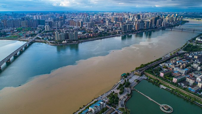
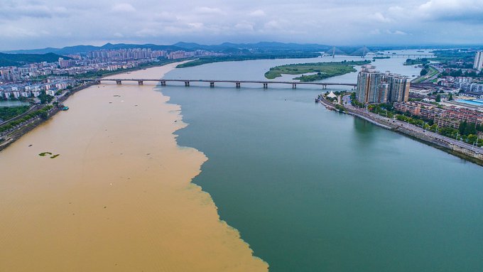
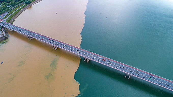
It’s so big, its basin which is the area of land drained by a river, and its tributaries cover 1/5th of China’s total land area! That’s a huge amount of land, some 700,000 square miles, which is in part down to the sheer number of tributaries the Yangtze has; more than 700 in total! These tributaries range from small streams to full-blown rivers, such as the Han River, which meanders along 952 miles before it flows into the Yangtze. But even then, you can still easily tell the two rivers apart as they create a stunning color divide!On the right is the clear blue water of the Han River. While on the left, the Yangtze looks like the whole population of China has dumped their morning tea into it! But that brown stain is actually muddy sediment like bits of sand, rocks, and dirt that the river has collected during its journey downstream.While it flows unimpeded, the Yangtze actually carries between 430 and 500 million tons of sediment down its channel every year! That’s heavier than all the concrete used to construct the Burj Khalifa, the tallest building in the entire world!
The colossal load of sediment makes the water of the Yangtze incredibly dense, and as a result, the clear water of the much shorter Han River can’t immediately mix with it, creating the dividing line. Instead, the two rivers flow alongside each other after they meet! Eventually, they mix together further downstream as the sediment gradually disperses.However, the incredible color contrast isn’t just unique to the Yangtze! A near identical effect occurs with the confluence of South America’s
Inírida and Guaviare rivers! The video below shows the sediment-rich waters of the Inírida River flowing into the Guaviare River, which itself is a tributary of the Orinoco River!
Amazon Colombia Orinoco river and Inírida River by Mygo Mygo Similar to the Yangtze, the Orinoco is one of the longest rivers in its land, stretching 1,400 miles across Colombia and Venezuela! But we can’t talk about big rivers in South America without addressing
the almighty Amazon! The gigantic river stretches at least 4000 miles long, the 2nd longest river on the planet; behind only the Nile River which beats it marginally at 4,132 miles.But while the Nile has more length, the Amazon has more tributaries, with over 1,100 of them feeding into its channel! And with such a large waterway comes some spectacular confluences. Such as the Meeting of Waters where the black water of the Rio Negro merges with the sandy Rio Solimões;
yet another tributary of the Amazon River.
Over 3.7 miles, the two rivers run side by side with one another without mixing, creating this incredible yin-yang effect! This phenomenon is due to the differences in temperature, speed, and volumes of sediment in the two rivers. Due to the inclines it runs down, the main River Solimões flows at a steady 2.5 to 3.7 miles per hour; the average pace of walking.While the Rio Negro, whose channel doesn’t follow such a steep incline, is slower at an average speed of 1.2 miles per hour. And it’s the river’s sluggish pace that also causes its dark-colored water. As the River Negro flows through the surrounding rainforest, vegetation falls in and decays, leaching dark-colored chemical components called tannins into the water.

It’s the same effect as brewing a cup of tea, but don’t get the river’s black water confused with your Earl Grey! The decayed vegetation makes the water highly acidic, with a pH high of 2.9 equivalent to the acidity of grapefruit juice! While that sounds kind of dangerous, confluences such as the Meeting of Waters are actually vital for wildlife because this color clash mixes up nutrients in the water! In fact, along the Rio Solimões’ 1000-mile length, the diversity of electric fishes, such as eels and catfish, increases closer to confluences, due to the increased richness of nutrients and organic matter.But depending on activity in the surrounding basin, the rivers can appear in a variety of different colors when they meet! Such as, the clear water from Granite Creek flows into the muddy
Hoback River at their confluence in Wyoming, USA.
The brown, almost red water of the Hoback comes from landslides which happened further upstream, giving its waters an even greater makeup of sediment. Or in the image below, at the color-clashing confluence of
the Rhone and Arve Rivers in Switzerland.
The deep blue of the River Rhone clashes with the denser milky green water of the River Arve, which is full of white sand sediment! But the best things always come in threes, as demonstrated by the famous
Passau confluence. Located on the German-Austria border, the place where several rivers combine with amazing triple colors!The thinner, darker stream on the far side is the River Ilz, which has dark-colored water because its basin contains the Bavarian Forest in Germany, collecting decayed plant debris and peaty soil from the surrounding forest.
While on the other side, a bold green river is the River Inn, which flows directly from the Alps Mountain range, where it picks up a high concentration of calcium carbonate from the surrounding limestone and gains that incredible turquoise color.
The River Ilz and Inn are both tributaries feeding into the River Danube in the canter. Though you may have noticed the River Inn is actually pushing the Danube aside, with green encroaching more on the blue. That’s because the River Inn actually contains 5% more water due to seasonal glacier melt, and this initially overwhelms the confluence meeting.
But the Danube River eventually straightens things out, as the three rivers intermix into its main channel. From there it carries on its journey along its 1,770-mile length, making the Danube River the second longest river in Europe. It spans over ten countries from Germany to Ukraine, before reaching its final destination: the Black Sea.
Have you ever wondered what happens when a river collides with an ocean? The color difference is even more extreme! As you can see in the image below, which shows the point where British Columbia’s Fraser River meets the marine waters.
It’s like the before and after of an Instagram filter! But don’t worry, neither of these bodies of water are editing their pics on Instagram! Rather, it all comes down to the suspended sediment in the river water, which is more visible in the sea due to the density differences between the two water bodies.
Seawater is a lot denser than a river’s freshwater, due to its high concentration of dissolved salt. This prevents the rivers from merging seamlessly where they connect, and so a sort of color clash occurs frequently wherever rivers meet the sea. However, these meetings can consist of more than just dull grey and black waters.For a more aesthetically pleasing color divide, check the image below where the Periyar River flows into the Indian Ocean at the Kochi Harbor in Kerala, India. The deep blue Indian Ocean forms a barrier against the mineral-rich Periyar River, again due to their density difference, so the water is only able to mix together gradually!
The mix of salty and freshwater is more commonly known as
brackish water, and is created within estuaries. It's an area where one or more rivers flow into a channel with an open connection to the sea. The two bodies of water flow into one another, and create a haven for flora and fauna alike!The high levels of nutrients from both the seawater and freshwater allow plants such as seagrass, mangroves, and microalgae to thrive. These plants, in turn, provide habitats for small fish and shellfish, which in turn provide food for creatures ranging from herons to sea otters!
We may have discovered what happens when rivers meet, but we’ve yet to dip below the surface to know just how weird the water can get!
Las Gachas Natural Plunge Pools
Rivers can host a ton of fun activities, from swimming to kayaking. But the last thing you’d expect paddling downstream is to crash into a giant hole! Rivers are literally channels of water. How can a liquid channel have a hole in it?
It defies everything we know about rivers, and yet
Las Gachas, located near the mountain town of Guadalupe in Colombia, is a small, shallow stream with dozens of holes lining its path. Given how perfectly round those holes are, you’d assume they were man-made. But they’re a completely natural feature!
The stream itself is exceptionally shallow, barely deep enough to cover your foot. The riverbed, however, is extremely slippery, and visitors have described it as like walking on butter, meaning it is not uncommon for people to fall into these plunge pools!The holes themselves vary in depth from just a few inches to more than 6 ½ feet deep! Whole families can fit in these larger pools, while the smaller pools can fit just one or two people.
Las Gachas plunge pools in Guadalupe Colombia by Tales of a Backpacker Another striking feature of the river is its ominous red color, which is due to a chemical oxide contained in the rocks, and not some sort of catastrophe that’s happened further upstream. Still, makes you wonder what else might be lurking in those holes! But the mystery remains, what or who made these giant holes?
It turns out they’re naturally occurring plunge pools, which are only caused by one thing, waterfalls! A plunge pool is a deep depression in a stream bed at the base of a waterfall. It’s created by the erosional forces of the cascading water plummeting down onto the rock below, wearing the riverbed down into a basin. The waterfall also carries loose rocks over the edge with it, which fall into the plunge pool and create a rock blender that erodes the plunge pool deeper. The waterfall also erodes itself, with the cascading water wearing down the overhanging rock lip of the waterfall. Over hundreds or sometimes thousands of years, the overhanging rock collapses and causes the waterfall to retreat further upstream, leaving a trail of plunge pools behind.

And it appears that this theory does hold water, as there are multiple waterfalls in the area! Including a waterfall further down the stream known as Cascadas del Caballero. The waterfall responsible for Las Gachas’ holes has long since retreated from the area, but left behind the hot tub riverbed!
River Of Sand
Back in November 2015, locals in the Ar Rub’ al Khali desert were shocked to discover a fast-moving flow of sand. But when they plunged their hand inside, they discovered something even weirder. It wasn’t sand at all, it was hail! Ice in the desert?
Sounds impossible, especially considering
the Ar Rub’ al Khali is the largest continuous sand desert on earth. Had some dumb tourist jammed the button too hard on a nearby hotel’s ice machine?
YouTube Video by Unknown
Though that would be a great story, it wasn’t a technical error. Rather, the fact is that it does rain in the desert occasionally, and the area had recently been hit by a terrible storm where hail the size of golf balls had pelted the region! To understand how such a crazy weather event could happen, we need to look inside the clouds. Hail is formed in thunderstorms that have an intense updraft. It is where warm air pushes water droplets inside a cloud higher up into the atmosphere, where the temperature drops rapidly. For context, the air temperature outside an airplane flying at 30,000 feet is typically -50°F. Whereas thunderstorm clouds can form even higher, at up to 40,000 feet! At this height, the water droplets freeze into ice. The heavy ice will then drop lower in the cloud, where more water droplets will smash into and collect around it. Depending on the strength of the updraft, it can then be swept back up into the cold atmosphere and the outer layer of water droplets then freeze too. With each cycle, another layer of ice forms around a hailstorm, making it grow.Eventually, the hailstones are too heavy for the storm’s updraft to support, causing them to rain down. And so, the stronger the storm, the bigger the hail! In such case, the desert’s hot air had stirred up a super thunderstorm and amplified the hail-making process, causing the hail to grow to golf ball size.

Thankfully, these supersized hail stones fell in the desert rather than over a city, because hail of such size is dangerous! Large hail stones falling at speeds faster than 100 miles per hour cause more than $1 billion in damages every year, smashing up buildings, cars, homes you name it!
But why were the hail stones flowing like a river? There’s a simple explanation for that, they were being carried by a literal river underneath! The hailstones had collected into tributaries of the Euphrates and Tigris rivers that cross through the desert.
The hot temperature, averaging 117°F in the desert, had caused the hailstones to partially melt, resulting in them flowing over each other. Sand stuck to the wet hailstones as they gradually melted, so that from afar it appears to be a river flowing with sand!Unfortunately, this sort of freak weather may become more common across the globe! Extreme weather patterns like these are the result of the ongoing impact of climate change. So best to start carrying an armored umbrella around with you, as you never know what’s going to fall out of the sky next!
Underwater Brine
If you were looking for a river or a lake, your best bet would be to search for one on land. But it turns out, there is a whole load of hidden rivers in the last place you’d ever expect: underwater! Due to a combination of geological processes, in some places on the sea floor, thick deposits of salt can be found in the form of thick, white rivulets.
When the seawater above starts to seep into the dense salt, it forms concentrated brine. The brine is far denser than even the seawater, and sinks into depressions on the seafloor, creating huge, ultra-salty underwater lakes and even rivers!
The density of the brine prevents it from mixing with the seawater above, so it becomes severely depleted of oxygen. When a fish enters a brine pool, it attempts to “breathe” in the environment, but due to the total lack of oxygen, it immediately begins to suffocate.
Simultaneously, they go into toxic shock from the huge concentration of salt. So, if the fish can’t surface and swim away into the oxygenated seawater above in time, the brine pool becomes their grave. Scientists on remote-controlled rover dives have discovered brine pools littered with the remains of fish, crabs, and other organisms that dared to swim too close.
Exploring the Alien World of Brine Pools by OceanX What’s even creepier is that the dead creatures are then preserved for years without decay because again there’s no oxygen here, which prevents the process of decomposition. Every brine pool ever found seems to have a fish “graveyard” nearby.
La Jolla Fog Bank
In 2021, beachgoers were enjoying a sunny day on La Jolla’s coastline in California, when they spotted something rolling in on the horizon. Was it a cloud? A ship? No, it was a towering tsunami!
The 100 ft wave rolled across the ocean at a rapid pace, reaching the shoreline in only 15 minutes! But as they braced for the monster wave to crash, they realized it wasn’t a wave, it was a giant fog bank! Nature’s most terrifying prank.
This phenomenon is known as a fog tsunami, and it occurs on beaches all over the world, occasionally looking like something straight out of a disaster movie about to destroy the city! La Jolla’s intimidating fog bank stretched 26 miles along the coastline, and was so tall it blocked out the sun!Fog banks can become so huge they’re even visible from space! Luckily, the fog itself is completely harmless, though it may make things a little difficult to see. Giant waves of fog descending over whole cities can reduce visibility instantly, making it dangerous for drivers, pilots, and ships!
Fog tsunamis can form quickly on sunny, cloudless days, seemingly out of nowhere. But they are actually a type of advection fog. The process occurs in the summer months, when long sunny days heat up the land creating warm, moist air currents. The warm air passes over the cold surface of the ocean, where the water vapor condenses into a giant blanket of fog.

The fog tsunami forms its distinctive wall shape due to a sea breeze front, where hot air from the land meets the colder air from the sea. These opposing air fronts create an invisible boundary, forming the fog into a large wall, which then slowly moves toward the land.
Colombia's Rainbow River
Located in Sierra de La Macarena National Park is Cano Cristales; a 62-mile stretch of waterfalls, rivers, and streams that, if you visit at the wrong time of year, appear dark green and a little boring. But between June and November, the river bursts into a rainbow of colors!
The waters ripple with a vibrant spectrum of purples, pinks, yellows, and greens that practically paint the riverbed. What causes this colorful wonder is a rare aquatic plant that grows in the water, called Macarenia Clavigera. And the plant doesn’t just return with the same style every year.

Due to the delicate nature of the ecosystem, the plant’s growth and color are determined by the year’s rainfall, temperature, and sunlight. As a result, the river blooms in different color combos every year! A stretch of the river may be a deep crimson, then come back the next year bright green or yellow!
The Macarenia Clavigera is an incredibly rare plant, with its unique nature supported by the 1.7 billion-year-old rock formation of the Cano Cristales riverbed! This prehistoric rock was formed by sediment from a series of ancient rivers, making it super rich in minerals such as phosphorous, iron, and quartz. And it’s that rare, mineral-rich bedrock that makes it a perfect place for the plant to grow.

Unsurprisingly, when you have something as picture-perfect as the Cano Cristales, it attracts tourists! Even if they have to hike through the wilderness to get to it, those influencers are determined to get their rainbow river selfie. But they might not be so eager when they realise, they have to go makeup free!To help conserve the environment, park authorities now prohibit visitors from wearing any chemical products that could contaminate the water, including sunscreen, insect spray, deodorant, and makeup! Not that anyone’s eyeshadow is going to beat the vibrant colors of this river!
If you were amazed at what happens when rivers meet, you might want to read our article about
unsettling water phenomena. Thanks for reading!